
CHARLESTON, SC – Tropical storm warnings have been issued for large portions of the South and North Carolina coastlines as Tropical Storm Chantal gathers strength over the Atlantic and tracks toward a weekend landfall.
- Storm Location and Strength – As of Friday morning, the National Hurricane Center (NHC) places Tropical Storm Chantal approximately 250 miles southeast of Charleston, with maximum sustained winds of 65 mph.
- Official Warnings – A Tropical Storm Warning is in effect from Savannah, Georgia, to the Outer Banks of North Carolina, indicating that tropical storm conditions are expected within 36 hours.
- Primary Threats – The primary threats associated with Chantal are heavy rainfall leading to flash flooding, dangerous storm surge along the coast, and strong, gusty winds capable of causing power outages.
Federal and state officials are urging residents in the storm’s path to finalize their emergency preparations as the window for action begins to close.
The Data for Decision-Making
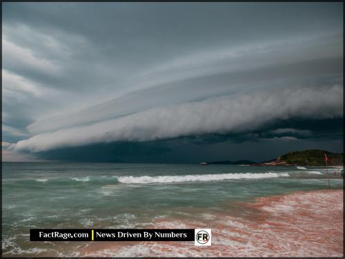
![]() As a storm system approaches, access to clear, verified information is critical for safety. The purpose of this report is to strip away speculation and provide only the essential data points from official sources. The following facts regarding Tropical Storm Chantal’s path, strength, and associated warnings are provided to support immediate and informed decision-making for those in the affected areas.
As a storm system approaches, access to clear, verified information is critical for safety. The purpose of this report is to strip away speculation and provide only the essential data points from official sources. The following facts regarding Tropical Storm Chantal’s path, strength, and associated warnings are provided to support immediate and informed decision-making for those in the affected areas.
What Is the Official Forecast for Chantal’s Path and Intensity?
According to the latest advisory from the National Oceanic and Atmospheric Administration’s (NOAA) National Hurricane Center, Tropical Storm Chantal is moving northwest at approximately 12 mph. The official forecast track, often called the “cone of uncertainty,” projects the storm will make landfall late Saturday evening somewhere along the coast of northern South Carolina or southern North Carolina.
Forecasters note that some additional strengthening is possible before landfall. Maximum sustained winds are currently 65 mph, just 9 mph below the threshold for a Category 1 hurricane (74 mph). The NHC states that while Chantal is not expected to reach hurricane strength, residents should be prepared for winds strong enough to cause damage to trees and power lines.
Which Areas Are Under Active Warnings?
A Tropical Storm Warning is currently in effect for a significant stretch of the southeastern U.S. coast. This includes the cities of Savannah, Charleston, Myrtle Beach, and Wilmington. A warning means that tropical storm conditions—defined as sustained winds of 39 to 73 mph—are expected in the area within 36 hours.
In addition to the wind threat, authorities have issued a Storm Surge Watch for coastal areas from Edisto Beach, SC, to Cape Lookout, NC. This indicates the possibility of life-threatening inundation from rising water moving inland from the coastline. The NHC is forecasting a potential storm surge of 2 to 4 feet above normal tide levels. Widespread rainfall totals of 4 to 8 inches, with isolated amounts up to 12 inches, are also expected, creating a significant risk of flash flooding.
How Are Officials Recommending Residents Prepare?
Emergency management agencies at the state and local levels are advising residents not to focus on the exact center of the forecast track, as impacts will be felt far from the storm’s core. While no mandatory evacuations have been ordered as of Friday morning, officials are urging those in low-lying, flood-prone areas to be ready to move if voluntary or mandatory orders are issued.
The Federal Emergency Management Agency (FEMA) advises the public to take several key preparedness steps:
- Build a Kit: Have an emergency kit with water, non-perishable food, a flashlight, batteries, a first-aid kit, and any necessary medications.
- Secure Property: Bring loose outdoor items like furniture and decorations inside. Secure windows and doors.
- Stay Informed: Monitor official sources like NOAA Weather Radio and local news for the latest updates and instructions from authorities. Do not rely on social media for official warnings.
- Know Your Zone: Understand your local evacuation zone and have a plan for where you will go if an evacuation is recommended.
A Developing Situation
![]() Tropical Storm Chantal remains a dynamic and evolving weather event. Conditions, including the storm’s track, intensity, and associated threats, are subject to change based on new data. Residents in the affected regions should continue to monitor advisories from the National Hurricane Center and directives from local emergency officials. This desk will provide further updates as confirmed information becomes available.
Tropical Storm Chantal remains a dynamic and evolving weather event. Conditions, including the storm’s track, intensity, and associated threats, are subject to change based on new data. Residents in the affected regions should continue to monitor advisories from the National Hurricane Center and directives from local emergency officials. This desk will provide further updates as confirmed information becomes available.
")


