
FACTRAGE – Recent severe weather outbreaks have brought the term “supercell” into the headlines, a name reserved for the most organized and dangerous class of thunderstorm.
- The Defining Feature – Supercells are distinguished from all other thunderstorms by the presence of a mesocyclone, a deep and persistently rotating updraft that acts as the storm’s engine.
- The Critical Ingredient – The storm’s rotation is created by vertical wind shear—a change in wind speed and/or direction with height—which is not present in the formation of ordinary thunderstorms.
- Disproportionate Threat – Though rare, accounting for a small fraction of all thunderstorms, supercells are responsible for a high percentage of severe weather events, including the vast majority of strong to violent tornadoes and giant hail.
These powerful storms are more than just intense weather; they are a unique atmospheric phenomenon with a specific structure and set of ingredients. Understanding their mechanics reveals why they pose such a significant threat.
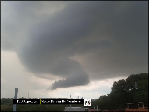
The Blueprint for a Perfect Storm
![]() The term ‘supercell’ signifies more than just a powerful storm; it describes a specific and elegantly structured atmospheric engine. Understanding its mechanics—the precise interplay of moisture, instability, and wind shear—is fundamental to modern weather prediction. This knowledge not only helps explain the immense power seen in recent headlines but also pushes science to the frontier of a critical question: how will these engines of destruction evolve on a changing planet?
The term ‘supercell’ signifies more than just a powerful storm; it describes a specific and elegantly structured atmospheric engine. Understanding its mechanics—the precise interplay of moisture, instability, and wind shear—is fundamental to modern weather prediction. This knowledge not only helps explain the immense power seen in recent headlines but also pushes science to the frontier of a critical question: how will these engines of destruction evolve on a changing planet?
Read On…
The following analysis breaks down how a thunderstorm learns to rotate and what makes it so uniquely dangerous.
What Sets a Supercell Apart From a Normal Thunderstorm?
On a basic level, all thunderstorms form when warm, moist, unstable air rises rapidly into the colder atmosphere above. In a typical thunderstorm, this rising air, or updraft, eventually gets choked off by the storm’s own rain-cooled downdraft, causing it to dissipate in 20 to 30 minutes.
A supercell is fundamentally different. The key distinction is its organized, rotating structure. This rotation, called a mesocyclone, is a vortex of rising air several miles wide that can extend deep into the storm. This rotation acts to separate the updraft from the downdraft. Instead of the rain falling back into the updraft and killing it, the downdraft is displaced to a different part of the storm. This separation allows the supercell to act as a steady-state engine, sustaining itself for hours and traveling for hundreds of miles while continuously drawing in more warm, moist air as fuel.
How Does a Storm Begin to Rotate?
The formation of a supercell requires a specific and relatively uncommon set of atmospheric conditions. In addition to the instability and moisture needed for any thunderstorm, the critical ingredient is strong vertical wind shear. This is a significant change in wind speed or direction as altitude increases.
Imagine the air in the lower atmosphere as a horizontal tube or rolling pin, set spinning by winds near the surface blowing in one direction while winds higher up blow faster or in a different direction. When a powerful updraft from a developing thunderstorm rises, it can tilt this horizontally spinning tube of air into a vertical position. This process creates the vertically rotating column of air that becomes the storm’s mesocyclone. It is from the base of this mesocyclone that the strongest tornadoes are most likely to form.
Is Climate Change Making These Storms More Frequent?
The question of how a changing climate impacts supercell frequency and intensity is a major focus of meteorological research. The connection is not simple. On one hand, fundamental physics dictates that a warmer atmosphere can hold more water vapor. Data from the National Oceanic and Atmospheric Administration (NOAA) confirms rising atmospheric moisture content. This increased moisture provides more latent heat, which is the fuel that powers thunderstorm updrafts, potentially leading to more intense storms.
However, the other key ingredient, wind shear, adds complexity. Some climate models suggest that the type of wind shear favorable for supercells might decrease in a warming world, potentially offsetting the effects of increased moisture. Yet, recent studies and observational data indicate that in some regions, including parts of the United States, the number of days with conditions favorable for severe thunderstorms has increased. The scientific consensus is that the environments that produce severe storms are changing, but forecasting the precise impact on the number and strength of supercells remains an active and challenging area of science.
Decoding the Atmosphere’s Fury
![]() The supercell represents a perfect, if terrifying, convergence of atmospheric physics. While we have decoded the fundamental mechanics of its rotating engine, the ultimate question remains: how will these powerful storms evolve on a warming planet? This intersection of known science and future uncertainty is where the most critical meteorological research now lies, directly impacting how communities prepare for the weather of tomorrow.
The supercell represents a perfect, if terrifying, convergence of atmospheric physics. While we have decoded the fundamental mechanics of its rotating engine, the ultimate question remains: how will these powerful storms evolve on a warming planet? This intersection of known science and future uncertainty is where the most critical meteorological research now lies, directly impacting how communities prepare for the weather of tomorrow.
")


